Satellite images emerge showing consequences of Ukrainian Defence Intelligence's strikes on Russian radar 1,800 km from border

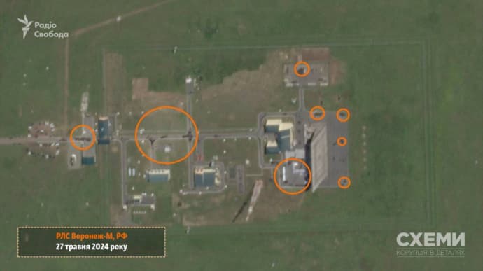
Journalists of Skhemy, a Radio Liberty project, have released satellite images from Planet Labs, revealing the consequences of a 26 May attack by Ukrainian Defence Intelligence drones on a Russian Voronezh-M long-range target detection station in Orenburg Oblast.
Source: Schemy
Details: The image dated 27 May reportedly shows that dark spots appeared on the radar's territory that were not there before. The Skhemy journalists suggest that these are traces of a fire caused by a UAV strike. In addition, the project noted that the photo's resolution does not allow for assessing the extent of possible damage to the Russian station.

Quote: "This radar station is located over 1,800 km from the border with Ukraine. Open sources indicate that Voronezh-M is part of Russia's long-range stationary over-the-horizon radars. They are designed to detect space and aerodynamic objects, such as ballistic and cruise missiles. This radar has a target detection range of up to 6,000 km."
"Схеми" опублікували супутникові знімки наслідків атаки на радіолокаційну станцію дальнього виявлення цілей "Воронеж М" в Оренбурзькій області РФ , що знаходиться за 1,8 тис. км від України
— Українська правда ✌ (@ukrpravda_news) May 27, 2024
ВІДЕО: Проєкт Радіо Свобода "Схеми" pic.twitter.com/vB5KOoG2XY
Background:
- Ukrainska Pravda source in Defence Intelligence of Ukraine (DIU) said that a drone belonging to Defence Intelligence of Ukraine attacked the Voronezh-M long-range target detection radar station located in the city of Orsk in Russia’s Orenburg Oblast on 26 May.
- The source added that the drone travelled over 1,800 kilometres to reach this facility, setting a new record for the range of a kamikaze drone.
Support UP or become our patron!


